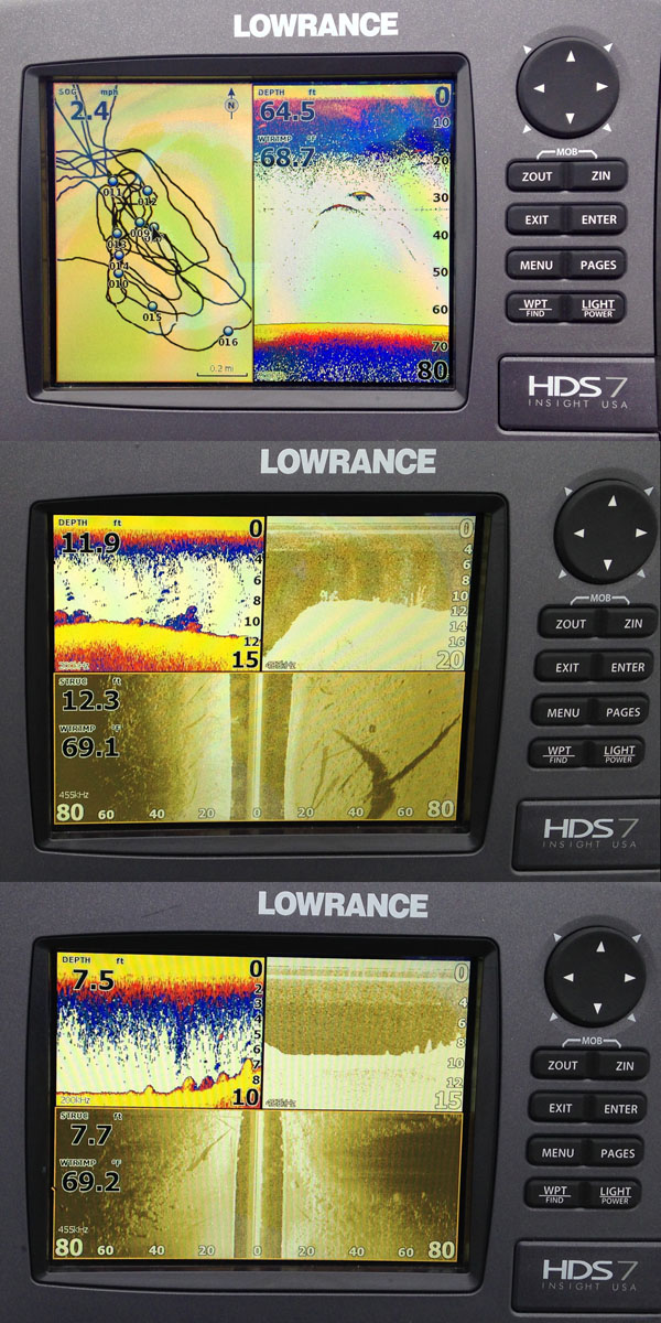
A recent tournament experience showed me that it was high time to replace my 13 year old Humminbird 400TX depth finder on my boat. This was a fairly high end unit when it was new and it has performed solidly over the years. I plan to either turn it into a portable unit for ice fishing and rental boats or give it to my father for his pontoon boat.
Criteria for my new unit included:
- Highest quality sharpness/detail sonar
- Focus on detail at shallower depths (I rarely fish deeper than 50-70 feet, even when running downrigggers)
- Built in GPS – chat plotter/need Canadian lakes hydro-graphic maps
- Temperature sensors/speed displayed
- Reasonable screen size – I need to be able to see the screen both at the tiller and while working the electric motor at the front of my boat
After a fairly lengthy study I decided to splurge and bought a Lowrance HDS-7 Gen2 with StructureScan HD. This unit came bundled with two transducers (the standard 83/200 kHz and the StructureScan HD transducers) and the Insight USA map set. I also added to this a Navionics Gold map set which added detailed maps of the Canadian waters I fish.
After putting this unit through its paces over the last few months I must say that I am extremely impressed with this unit, well worth the cost. The standard transducers worked beautifully marking suspending fish and bait schools. We also used it to track downrigger depths during trolling and could even mark our jigs beneath the boat while drift fishing. The screen is easy to read and allows for three split screen positions on the HDS-7. The larger screen units, HDS-8 and 10 allow for four quadrants to be used.
The GPS is extremely accurate and easy to use. On a recent lake trout trip trolling an unmapped lake I would add a waypoint every time we had a bite or caught a fish. After a day or two it was pretty clear where the most productive water was allowing us to fine tune our trolling pattern. It also helped keep us away from shallower areas, reducing the amount of raising and lowering cannonballs during the day.
My son tells me that the StructureScan HD is “just cheating” and I’m almost inclined to agree. Rocks, logs, weeds and fish all show up on this in great detail off to both sides of the boat (up to 250 ft). Transitions in bottom hardness/types were also easily discernible. In the DownScan view suspended fish show up as bright white “chicklets” on the screen and on a recent trip we were able to follow and catch schools of perch using this view. Weeds are also easily distinguished in this view as well.
Sonar settings are configurable for the type of fishing you are doing (e.g. shallow or deep water, slow or fast trolling, etc.) and a variety of color palettes allow you to customize the look of the graph. Water temperature and speed (from the GPS) are also shown. I’m still exploring some of the more advanced functions of the unit, I’m particularly intrigued by the mapping options that overlay obtained StructureScan data. As always, more time on the water is needed…


